
Have you ever wondered what kind of cloud you’re looking at? Maybe even what it means for your forecast? People have been looking to the skies for clues about the weather since the dawn of time, though it’s easy to neglect what clouds might be telling you in this age of smartphones and their weather apps. If you’re interested in learning more about the different types of clouds and how you can better read the sky for clues about your weather, you have come to the right place!
How Are Clouds Classified?
According to the World Meteorological Organization’s International Cloud Atlas, more than 100 types of clouds exist. But they can be grouped into ten basic types based on height and shape.
Clouds that are high enough to be composed entirely of ice crystals, even during summer, are given the “cirro-” prefix derived from “cirrus,” which is Latin for a lock or tuft of hair. It is a good way to describe the visual appearance of these clouds. These clouds are generally found above 23,000 feet in altitude.
- Cirrus
- Cirrocumulus
- Cirrostratus
Mid-level clouds that contain a mix of liquid water droplets and ice crystals are given the prefix “alto-.” While alto means “high” in Latin, it is more popularly known as meaning “middle,” given the musical associations with the modern Italian translation. These clouds are generally found between 6,500 and 23,000 feet in altitude.
- Altocumulus
- Altostratus
Low-level clouds close enough to the ground to be made up of primarily liquid water droplets are generally given the prefix “strato-,” which means “layer” in Latin. Cumulus clouds are also located near to the ground and are primarily composed of water, though they have a distinctive heaped shape with more vertical depth. Cumulus is Latin for “heap.” These clouds are generally found below 6,500 feet in altitude.
- Stratus
- Stratocumulus
- Cumulus
The two primary cloud types that don’t fit neatly into these vertical categories are associated with precipitation. Nimbostratus clouds generally occupy the low and middle parts of the atmosphere and produce light to moderate rain. On the other hand, cumulonimbus clouds can span the full depth of the atmosphere and produce very heavy rain in addition to other severe weather hazards like lightning, hail, damaging winds, and tornadoes. Both include the “nimbus” prefix/suffix, which is Latin for “cloud,” though the common thread between these two cloud formations is their ability to produce precipitation.
- Nimbostratus
- Cumulonimbus
You can get a general sense of these different cloud types with this diagram:
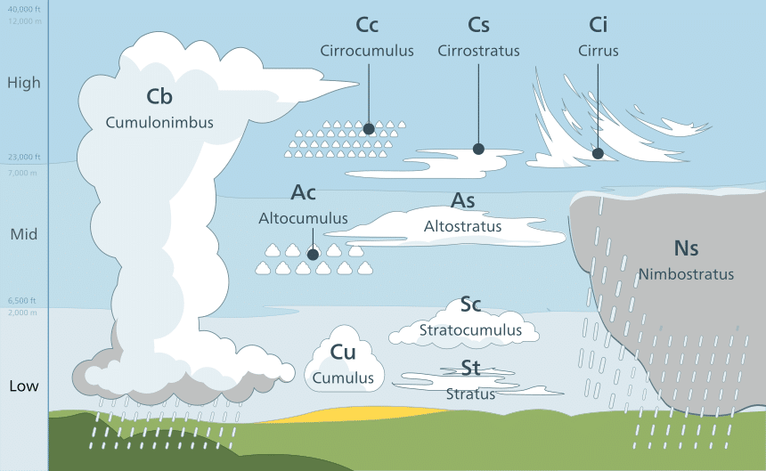
The 10 Different Types of Clouds
Now that you know a bit more about the general classification scheme, let’s discuss each major type of cloud in more detail.
1. Cirrus

Cirrus clouds are thin, wispy, high-altitude clouds that are often visible on quiet weather days. Cirrus often develop from the tops of defunct thunderstorm clouds after the rest of the cloud has evaporated. The jet stream, a strong current of wind in the upper atmosphere, can blow cirrus clouds hundreds or thousands of miles from the stormy region that generated them. The strong jet stream winds also help shape these clouds into their classic long, thin, wispy shape. Most clouds in the image above are cirrus, especially near the top and the right.
When You’ll See Them and Weather Prediction
You’ll see cirrus most often on quiet weather days when no other clouds are in the way. In the extratropics, cirrus clouds are often your first sign that a string of calm weather is ending and storms are beginning to approach. A general rule of thumb is to expect precipitation 24-72 hours after you observe cirrus clouds, depending on your location and the time of year. That said, sometimes you can see cirrus clouds produced by a storm that will remain too far away to bring precipitation to your location. In the tropics, cirrus clouds are present pretty much all the time, given all the thunderstorm activity that part of the world is known for. Given their ubiquity, cirrus clouds don’t have any predictive value in the tropics.
2. Cirrocumulus
Cirrocumulus are high-altitude clouds with a bit more heaped or speckled texture than classic cirrus. Most clouds in the picture above, especially closer to the top and left, are cirrocumulus. Note they are higher in altitude than the low-level stratus/cumulus visible farther down and to the left in the image. However, they don’t have the smooth/wispy appearance of classic cirrus.
When You’ll See Them and Weather Prediction
Cirrocumulus are most common after cold frontal passages in the extratropics. In general, cirrocumulus clouds are a good indication that the worst of a storm is behind you and cooler, drier air is on the way. Cirrocumulus are very rarely if ever, observed in the tropics.
3. Cirrostratus
Cirrostratus clouds are a uniform layer of thin translucent clouds in the upper levels of the atmosphere. Uniformity is what sets cirrostratus apart from cirrus and cirrocumulus. The picture above shows how nearly the whole sky is covered by a uniform film of thin cloud that barely filters incoming sunlight. That “milky sky” look is the classic hint that you’re looking at cirrostratus.
When You’ll See Them and Weather Prediction
Cirrostratus are most common in the winter in the extratropics ahead of incoming storm systems. Typically they arrive after initial wispy cirrus clouds and are a signal that a storm is moving in.
4. Altostratus
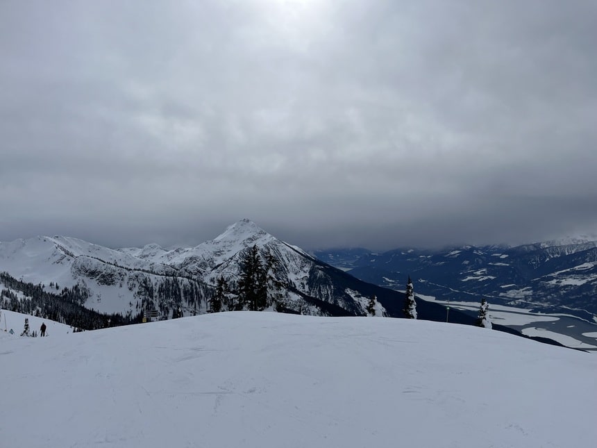
A bit thicker and a bit lower than Cirrostratus, Altostratus clouds come next in the gradual progression of lowering and thickening clouds as a winter storm approaches. You may be able to make out the faint outline of the sun through an altostratus deck, but it will be much darker than under cirrostratus clouds. The image above shows a thick altostratus layer above some mountains (this is how we know it’s not a stratus layer), with snow beginning to fall from the cloud base.
When You’ll See Them and Weather Prediction
Altostratus clouds are also primarily a wintertime phenomenon in the extratropics, and they usually signal an impending storm. Precipitation may begin falling from altostratus within a few hours of arrival, or it may take longer depending on how dry the air is near the ground.
5. Altocumulus

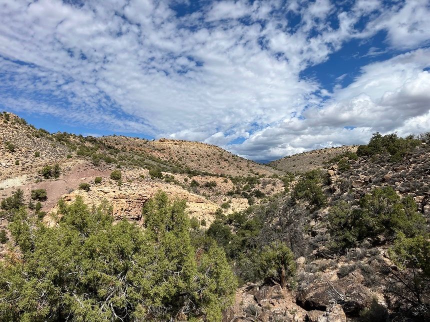
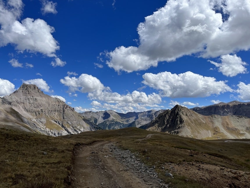
Altocumulus are heaped clouds that sit in the middle of the atmosphere, below the small speckled cirrocumulus but above the typical puffy cumulus clouds. This picture is an excellent example of some altocumulus on a summer afternoon in Washington State.
When You’ll See Them and Weather Prediction
Altocumulus are an indication of instability in the middle part of the atmosphere. Sometimes, though not always, this instability is released in the form of thunderstorms. As a result, if you see altocumulus in the morning, especially with considerable vertical depth (known as Altocumulus Castellanus or “towering altocumulus”), be on the lookout for thunderstorms later in the day. Altocumulus can occur any time of year and any time of day but are most common on spring and summer mornings.
6. Stratocumulus

Stratocumulus is a category that describes a cloud that’s too puffy to be pure stratus but too short/layered to be a classic cumulus. The clouds in this photo are a good example. Note how there’s some puffiness/separation between adjacent clouds, but not so much that it looks like a field of fair-weather cumulus. Especially towards the right of the image and farther in the background, these clouds congeal into more of a layer. This is classic stratocumulus.
When You’ll See Them and Weather Prediction
Stratocumulus clouds are common behind extratropical cold fronts, especially during the fall and winter. You can also see them near the periphery of tropical or subtropical storm systems, but this is less common. Coastal regions in the mid-latitudes and subtropics are especially known for stratocumulus, which is widespread over the ocean. Stratocumulus is rare in the tropics. Generally, stratocumulus is fair-weather clouds, though they indicate the presence of enough low-level moisture that you should keep an eye out for fog, drizzle, and/or light rain.
7. Cumulus
The classic fair-weather cloud, cumulus clouds, develops generally under sunny skies when the ground heats up enough to generate upward air currents. As the air in these currents rises, it cools, and the little moisture it contains can condense into clouds. Most cumulus clouds are fairly shallow and don’t produce rain, but occasionally, they can grow taller and become a rain threat.
When You’ll See Them and Weather Prediction
Cumulus clouds can happen anywhere at any time of the year, but they’re most common in midday and early afternoon. They usually indicate quiet weather, but sometimes they can be the first sign of developing thunderstorms. Watching their vertical depth is the key to determining if you might get wet. If they’re wider than they are tall, like those in the picture above, you’re probably safe. If they’re becoming taller than they are wide, you should prepare for raindrops.
8. Stratus

Stratus clouds are uniform low-level clouds that are not producing precipitation. They are relatively featureless when observed from the ground, as seen in the image above.
When You’ll See Them and Weather Prediction
Depending on the atmospheric context, stratus clouds may be an innocuous nuisance. Or it may precede rain and/or snow. Because stratus clouds are so featureless, it’s hard to make any inferences about what its presence might mean for your future weather.
9. Nimbostratus
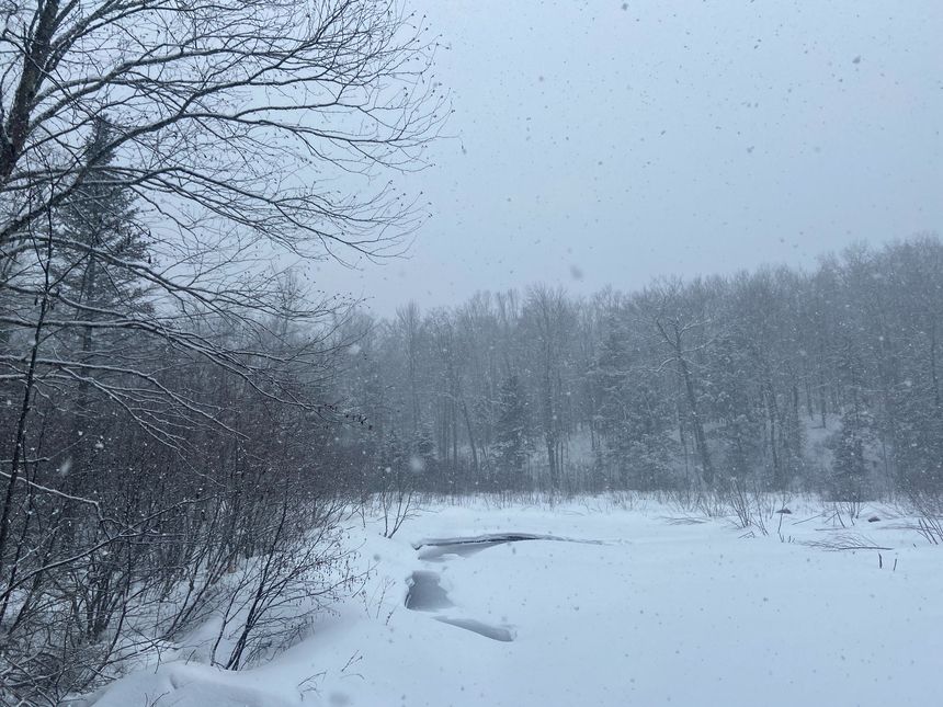
Nimbostratus is by far the least exciting cloud to look at because it’s basically just a thick slab of uniform gray out of which precipitation falls. This is what it might look like in the winter when temperatures are cold enough for snow.
When You’ll See Them and Weather Prediction
You’ll see nimbostratus in the heart of any mid-latitude storm system. These are most common in the fall, winter, and spring but can happen at any time of the year. Nimbostratus becomes much less common as you move toward the tropics. If you’re looking at nimbostratus, you are also looking at (by definition) rain and/or snow. Given how featureless these clouds are when observed from the ground, there’s really no way of telling how long the rain might last based on the appearance of nimbostratus.
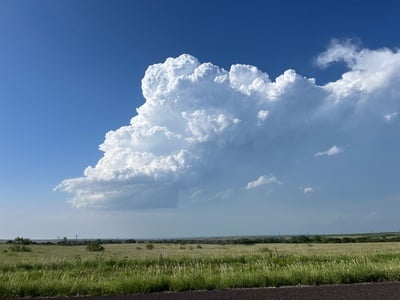
10. Cumulonimbus
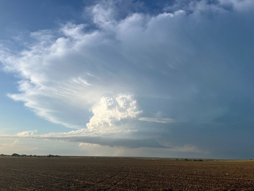
Last but by no means least, cumulonimbus is the name given to what is popularly known as “thunderheads” or “thunderstorm clouds.” These are heaped like cumulus, except they extend much higher into the atmosphere than the fair-weather cumulus discussed above. The picture above shows a classic cumulonimbus with a dark base made up of liquid cloud droplets near the ground and a thin, light, wispy top made up of ice crystals at the top of the troposphere.
When You’ll See Them and Weather Prediction
Cumulonimbus clouds need atmospheric instability to develop, which depends on temperatures and moisture being much higher near the ground than in the atmosphere. This instability can happen any time of year and any time of day in the tropics, but cumulonimbus clouds are a bit harder to find in the extratropics. Generally, spring and summer are prime times for cumulonimbus in the United States. Late afternoon and early evening are also the most common times to find cumulonimbus outside of the tropics, though if conditions are right, they can occur any time of day.
If you spot a cumulonimbus cloud, you may experience dangerous weather imminently! Cumulonimbus clouds can produce heavy rain, lightning, gusty winds, and even hail and/or tornadoes if atmospheric conditions are favorable. If you see a cumulonimbus cloud nearby, especially if it’s moving in your direction, seek shelter as soon as possible!
Other Interesting Cloud Types
In addition to the standard cloud types and their various subspecies, a few other interesting cloud types are worth discussing. Most of these develop in or near strong thunderstorms and can provide clues about the storm’s behavior. Observations of some of these clouds, especially wall and shelf clouds, can help expert meteorologists issue timely warnings for severe weather like tornadoes.
1. Wall Cloud
Wall clouds are low-hanging clouds that emerge from the base of particularly intense cumulonimbus clouds. They occur because upward motion in the thunderstorm’s core is so intense that a localized pocket of low-pressure forms near the storm’s base. Because invisible water vapor condenses into visible cloud droplets more easily at lower pressures, a wall cloud can extend closer to the ground than the prevailing cloud base.
When You’ll See Them and Weather Prediction
You will only ever see a wall cloud if you’re underneath (or very close to) a very intense thunderstorm. Thus if you see one, it’s time to take cover! Very hazardous severe weather is likely to occur very soon. Wall clouds nearly always precede tornado development, but not every wall cloud produces a tornado. If a thunderstorm were to produce a tornado, it would generally emerge from the base of the wall cloud.
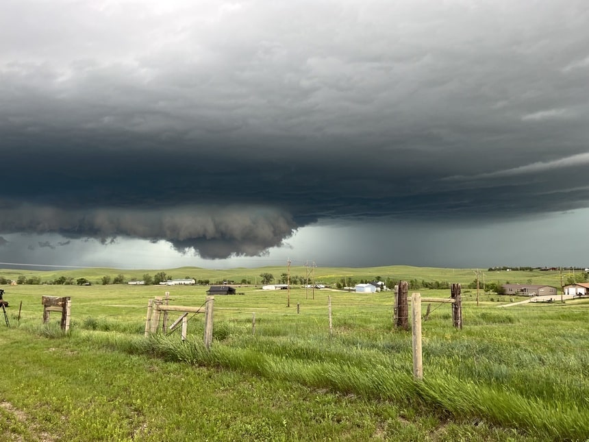
2. Shelf Cloud
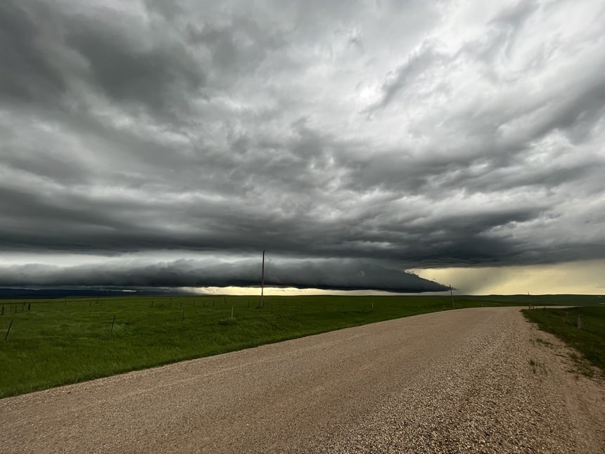
Shelf clouds are another type of cloud that emerges from the bottom of strong thunderstorms. However, unlike the wall cloud, shelf clouds are driven by cold air rushing out of the bottom of a storm rather than warm air rushing into the storm. As the cold air rushes out, it displaces warm moist air upwards, where it cools and condenses. Thus a shelf-like cloud forms along the leading edge of the pool of cold air produced by rain from the thunderstorm.
When You’ll See Them and Weather Prediction
You’ll be able to spot shelf clouds any time a thunderstorm produces a sufficient amount of cold air that needs to rush out of the cloud base. Some shelf clouds come along with powerful winds from this cold air, but that’s not true for every shelf cloud. Some may pack little more than a light breeze and a slight drop in temperature. There’s really no way to tell for sure based on the cloud formation, though shelf clouds with robust horizontal and vertical continuity like the one pictured above generally will pack stronger winds than a more ragged shelf cloud.
3. Fog

Fog is merely the name we give to a cloud—any cloud—when it makes contact with the ground. Stratus, cumulus, nimbostratus, whatever the cloud was before it hit the ground, becomes fog as soon as it makes contact. The fog pictured above occurred when some stratus clouds moved in off the Pacific and made contact with the Oregon coast.
When You’ll See Them and Weather Prediction
There are two basic types of fog: “radiation fog” and “advection fog” in meteorological parlance. Radiation fog occurs when heat radiates away from Earth at night, and the temperature cools just enough to cause near-surface water vapor to condense into water droplets. This type of fog is most common late at night and early in the morning and can occur just about anywhere. Advection fog occurs when warm air is pushed (“advected”) over a cold surface, causing its moisture to condense. This cold surface is usually either snow or cold water. This type of fog is most common in the winter and spring along the Northeast Coast, West Coast, and the Great Lakes.
There’s no reliable inference you can draw about your upcoming weather from the presence of fog. If you’re looking at radiation fog, you’re probably just a couple of hours away from clear skies and a bright sunny day. If you’re looking at advection fog, you could be socked in for days, and a storm might be on the way too.
4. Mammatus
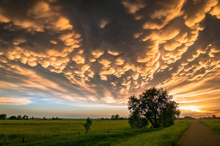
Mammatus clouds are unique cloud formations characterized by pouch-like shapes hanging beneath the base of a larger cloud system, usually large cumulonimbus clouds. They appear as clusters of distinct, bulbous structures resembling hanging udders or bubbles. These clouds are formed by sinking air pockets and turbulence within a larger cloud, often associated with thunderstorms.
When You’ll See Them and Weather Prediction
You’ll see mammatus clouds either in front of or behind a thunderstorm. If you’re looking at mammatus dropping out of the back of a thunderstorm, you can expect clear skies in the hours to come. If you’re looking at mammatus along the forward flank of a thunderstorm, expect heavy rain, lightning, gusty winds, and/or hail. Without more information about the environment surrounding a given mammatus cloud, it’s impossible to accurately predict your weather based merely on their presence.
5. Contrails

Contrails, short for condensation trails, are high-level clouds made up of ice crystals that form when water vapor is emitted by jet engines flying in a layer with the right temperature and moisture profile. These clouds are harmless and generally short-lived, though they can persist for several hours under the right conditions. They don’t tell you anything about the weather, given that human activities produce them.
Final Thoughts
With a bit of knowledge about the different cloud types, you can read the skies for clues about what weather you can expect in the coming hours or even days. Remember that these are just some of the many clues the atmosphere is giving you about what the future might hold. Temperature, wind speed, wind direction, and humidity are all additional clues a seasoned forecaster can use to make a prediction the “old-fashioned” way.
Even with all these clues, you’re still not going to be able to make the most accurate weather forecasts based on the clouds alone. It can be a fun party trick, but when it really counts, consult a forecast from a weather app or website produced with all the latest tools modern science has to offer.
If you’re looking to spot some clouds, I’d recommend the Great Plains of the US for the widest variety. Even though the cloudiest places in the US are situated in the Northwest and Great Lakes, most of their cloudy days come from stratus and nimbostratus, which aren’t very fun to observe.


